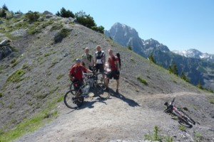
Mad Yorkshire Men (no dogs) Carry Bikes to Theth
Just a quick e-mail to let you know that we made it up and over the top (photo attached) and are now back in the UK. The top took us 5 hours from the farmhouse and then 2 hours to Thethi.
Many thanks again to you and everyone at Rilindja for your hospitality and assistance.
Kind regards, Graham


 Have you visited Valbona recently?
Contribute an entry!
To send your posts and photos
Some people met them on the trail and considered them mad, too 🙂 I’m curious if they enjoyed it in the end or not?
Hi Catherine,
We didn’t really carry the bikes, more pushing and lifting over rougher ground than carrying for any distance. Just as well given the heat!
Some of the other side was rideable but we probably pushed for about 3/4 of the way until we got to the farm track. If the track had been in the UK and with medical assistance closer to hand we would probably have ridden most of it, however in a remote area and with a pack on it’s a bit too risky.
One last thing to mention is how incredibly friendly and helpful we found everyone in Albania. When people have asked how our trip was the two things that I immediately mention are the beauty of the scenery and the people we met on our travels.
If your journal prompts any enquiries about biking in Albania I’d be happy to provide any information I can.
Once again many thanks,
Graham
Also this from 2013, thanks to Stefan Stuntz, who crossed in May:
The crossing is quite easy when the sun is shining and softens up the snow. You have to be comfy to hike/traverse steepish (30 degrees) snow fields. Snow starts in earnest at about 1400m altitude. Finding the correct way down on the Theth side is very(!) hard though. The path is completely buried until 1400m as well and there arent many visible waymarkings. I would consider it impossible to find without a highly accurate GPS and a good track to follow (or obviously a local guide).
And he posted great pictures here:
http://www.mtb-news.de/forum/showthread.php?p=10584894#post10584894
(you may have to search “Valbona” to make it pop up faster. Not sure – my connection is too slow and I get impatient!)