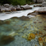
Know Your Mountains
![]()

To paraphrase Thomas Wolfe: ‘It’d take a guy a lifetime to know Valbona (“t’roo an’ t’roo”). And even then, you wouldn’t know it all.’ But nevermind knowing it all — even a couple of years ago, you could’ve come here, and had a hard time learning even the names of the mountains — Malesori are highlanders, and clannish, and while outrageously hospitable, also equally suspicious – if you asked the name of a mountain, I bet their reaction would’ve been “Why do they want to know? Tell them something — make it up!” And nevermind the mountains — how about knowing the mountain paths, that have been Malesoris’ private knowledge and best defense, since before the Balkan ‘conflicts’, before the Ottomans — before the Romans!
Well. We’re not going to give it all away here. And even with what we’re going to tell you, you can still get yourself plenty lost. But hopefully this is enough information to make you comfortable enough to plan and enjoy your stay.

We’ll start you off with just 5 mountains. These have kept Catherine busy for the last 2 years, so they ought to be enough to begin with! Kollata (2552 m), Rosi (2522 m), Pecmarra (2017 m), Gjarpri (2211 m) and Jezerca (2692 m). There are others — many, many others — once you start learning names around here, you might as well count the folds in a Malesori’s brain: Zhaborre, Çeta e Harushës, Brijasit, Malagashi, Hekurave, Thatë , but ignore those for now. And while you’re ignoring things, there are just the peaks with intimate names: Helli i Kuq, Ademi, Isuf Demes . . . . and of course the passes (“Qafa” in Albanian: Like in French, the word for pass is the same as the word for neck) Qafa e Kalit, Qafa e Gjesë, Qafa e Ndroqit . . . . But like we said, nevermind those for now!
 |
Kollata (2252 m) Dominating the Northern side of Valbona Valley, Kollata is a southern-facing, wide, sunny slope, and deceptively friendly. More often than not, the lush grass meadows are completely vertical. Best for: snow caves that survive the hottest summers and Chamois spotting. |
|
|
 |
Pecmarra (2017 m) North-facing, dark and craggy. Lower paths allow you to walk the Valbona River from Dragobi to Valbona Village, but on leaving the river paths become narrow and often skirt precipitous drops of several hundred meters. Lower slopes of dense beech forest perfect for Bear and Boar. Best for: Shpella e Dragobisë, abandoned Bauxite mines and a remarkable echo in Lugu i Silkut. |
|
|
 |
Rosi (2522 m) Beginning with a walk up Kukaj valley, Rosi offers beautiful meadows of rioting flowers, stunning views into Mal i Zi (Montenegro), and a good scrambling climb to the peak. Mostly pretty gentle and for once there aren’t any steep edges to fall off of. Best for: Botanists –meadows of the endemic Albanian Lily, wild Fritellaria, orchids and 1,000s of other flowers. |
|
|
 |
Gjarpëri (2210 m) “Snake Mountain” forms the eastern side of the Cerem Valley. A dirt car road goes around the western side to Cerem, from where you can continue on up to the stans of Markofshe. Or go the long way around to the east for plum orchards and great views. Best for: those who want to eat fruit, bear watching and to see how the shepherd families live in summer. |
|
|
 |
Jezerca (2692 m) The highest mountain wholey within Albania, Jezerca is technically in Shala (near Theth), but you can get there from here via several routes from Kukaj. The loop furthest north allows you to get to Theth by passing the Jezerca Lakes for those who like camping. Best for: “The Because it’s There” sort of hiker who enjoys remote lunar landscapes and sleeping rough. |
|
|
Some Notes on Walking in the Malësi (“highlands”)
Guides: Experienced, sensible hikers, confident with map, compass and/or GPS should feel free to explore on their own, without a guide. Guides do safeguard against the biggest dangers here, though: the high probability of getting lost, the dangers of precipitous drops on crumbly limestone and the difficulty of finding water — especially in the dry months of August and September. Although Valbona is a National Park on paper, there is no park staff or rescue equipment, and on many mountains cell phone reception is spotty which is why, if you have any doubt (or probably, my mother would say sense) you should probably consider at least starting with a guide.
Trail Markings: There have been several projects to mark trails in the last year or two. None of them have gotten very far yet, nor do any of them agree on a single marking system. There has also been an unfortunate tendency of enthusiastic visitors to begin marking things themselves with spray paint, but these marks are frequently confusing, peter out, and may even be in the wrong place. In general, it’s better not to rely on them but just be happy if they seem to agree with where YOU think you should be going. We’ll try to give you the best information on what you can trust.
Water: As mentioned, August and September are the dry months, and many springs (and even whole rivers) dry up completely. Many things marked as rivers on maps are actually places where there is water only when it rains. Plan on carrying as much water as you can.
Animals & Plants: There are many, many dangerous animals here — not so much Lions and Tigers and Bears (Oh My!), but lots of Wolves and Boars and Bears. And horned vipers, and several lethal plants (please do not sample the plump black berries of the Deadly Nightshade that grows in profusion!). But the animals at least are terrified of people, since they associate humans with guns, not picnic baskets, and unless you round a corner and run smack into a mother-something with its babies AND wave your arms in the air AND act nasty, THEY will run away from YOU if they possibly, possibly can. The plants, it has to be admitted, probably don’t know you exist.
A Note on Names: You’ll notice that Pecmarra also gets called Maja e Pecmarrës (Gjarpëri = Maja e Gjarpërit, etc.). This is the difference between saying “Pecmarra” and “The Mountain of Pecmarra.” It’s not so confusing once you get used to it! We use both here, so you can get comfortable with both names. Also, be aware that no orthographic system seems to have lasted for much longer than 50 years here and when you add that to the (quite large) differences between Northern (Gheg) and Southern (Tosk) Albanian dialects, what do you end up with? Maps that spell things every which way. That’s what. It’s not so bad, as long as you don’t expect things to be standard. Which is actually a pretty good rule of thumb for dealing with Albania, in general!


")


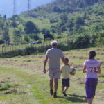 Valbona with Young Children?
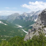 A Very Good Question! Where to Stay to Avoid the Hordes?
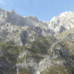 We visited in 2014 . . . .
 On the Dubious but nonetheless Glorious Triumph of Being [Recognized]
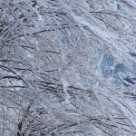 What Passion Feels Like
 Long Dark Days